Unprecedented mapping of radioactive barrels in the North-East Atlantic
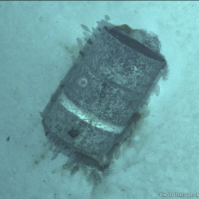
Supported by the CNRS as part of an interdisciplinary programme run by the MITI and funded by the French Oceanographic Fleet, the NODSSUM-I scientific mission, which took place from 16 June to 11 July 2025, mapped 3,355 radioactive waste barrels submerged between the 1950s and 1990s over an area of 163 km2 at a depth of nearly 5,000 m in the North-East Atlantic. Conducted aboard the ship L'Atalante, this international operation involved six scientists from IN2P3 and several of the institute's laboratories on land: LPCA, IPHC, Subatech and LP2I Bordeaux.
Thanks to the autonomous submersible Ulyx, 16 dives were carried out to document the state of preservation of the barrels, some of which were damaged, corroded or colonised by fauna. No anomalies related to radiation protection were found in the samples collected. Additional analyses are currently being carried out on the water, sediments and living organisms collected. A second campaign is planned for 2026 to further investigate the immediate vicinity of the barrels.
Useful links
- To find out more about the mission, visit the MITI site.
- More pictures in the IN2P3 photo library.